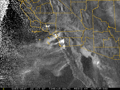
View of Southern California from the National Weather Service satellite. A little different perspective from what is being shown on the news. Click on image for latest shot from the National Weather Service
The fire has made its way into northern San Diego, burning homes in Rancho Bernardo. Our area of Ramona is basically untouched as of Monday morning, according to sources in the area. I am currently logged in to a server that is still up in our house, so we haven’t even lost power there.
Doug,
What part of Ramona are you from? I’m wondering if you could advise on the status on the West end. My grandfather is on Archie Moore Road near 67, just accross Archie Moore from Mt. Woddson Country Club. Thanks.
Gregor Peterson
Hi Gregor,
I heard that the Archie Moore Road area was evacuated at one point, but I do not know if that area was touched by the fires. I wasn’t able to go through that area on my way out of Ramona. I had to leave via Wildcat Canyon Road through Barona.
dr
Hey Doug,
So glad you have this site and that you are still have power. Most importantly that you and Django are safe and sound. Keep safe!
T